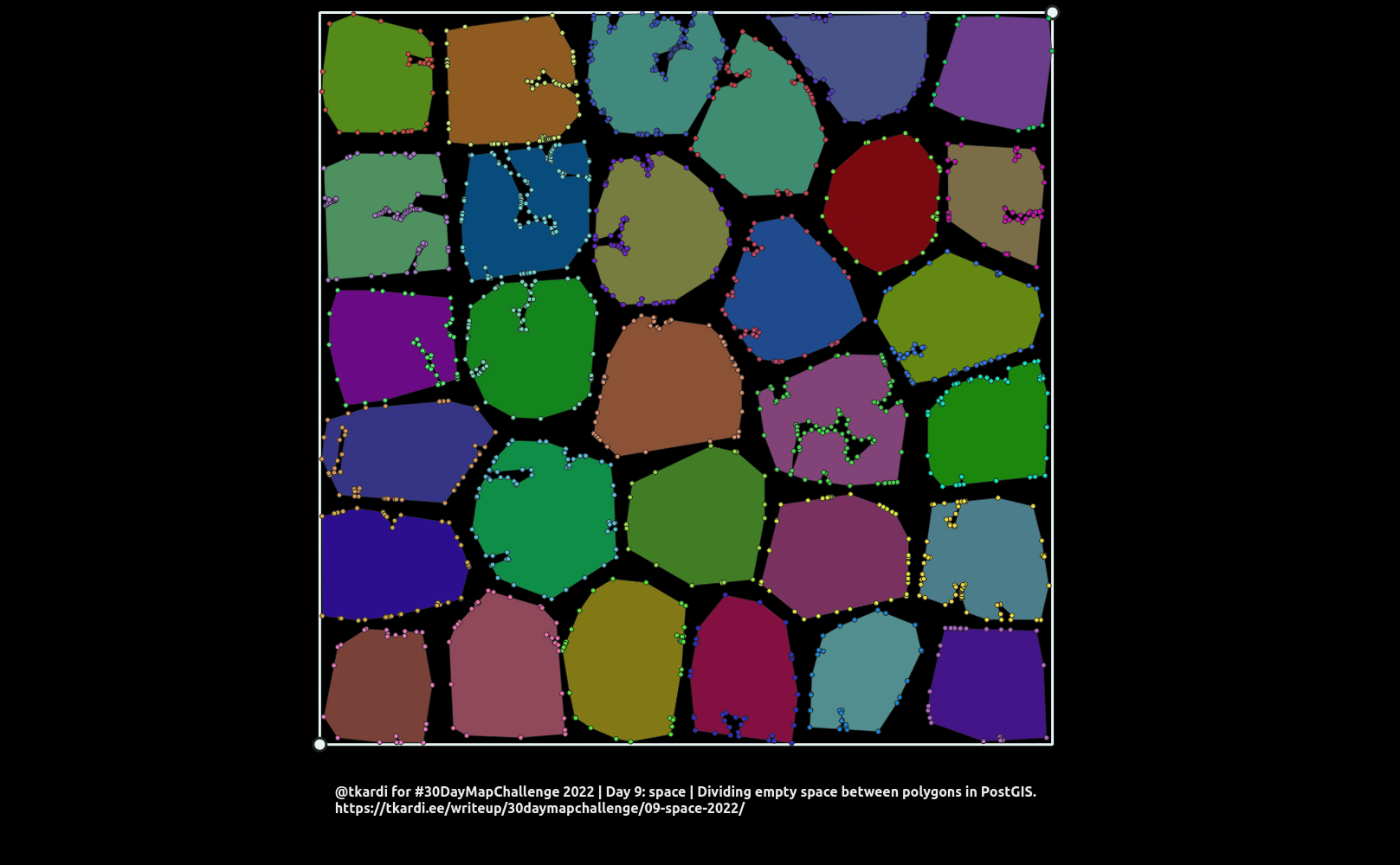
2022 / Day 09: Space
I wrote a little something about this same subject a few years ago in the context of expanding admin unit polygon boundaries out to the sea using coastline vertices. And for a nice homogeneous dataset it works really nicely. Now if you apply the same thing in a different kind of situation (e.g. filling in holes between cadastral parcels of varying sizes and most importantly with varying amounts of vertices on the sides facing but not quite touching each other) it might not be the most suitable solution.

In todays challenge I will try to tackle the problem of saw-teeth that arises from… too little points. But that said, adding more vertices to polygon boundary will only make the saw-teeth finer in resolution and will not deal with the problem.
Todays output image will be an animated gif showing the different stages (CTE results) that the query produces. The query itself (see below) is still a oneliner.
The query itself starts off again with defining the minmax corners, and
constructing a bounding geometry into bounds using
st_envelope. Then generating a
bunch of random points (st_generatepoints)
and clustering them with st_clusterkmeans
into clusters. Now in order to get concave polygons instead of convex ones
st_concavehull is used with
0.0 produce a hull of maximum concaveness as areas. For extra fun.
So far so good. Until now we’ve produced only the testing dataset. This is where we start the real processing.

First off, extract all area boundary vertices with
st_dumppoints,
and keeping in mind that the boundary linestring extracted with
st_boundary will have
first and last points in the same location so
filter last one out using the number of vertices per geometry calculated by
st_numpoints.
All of this is in the CTE called pts.

Secondly, we’ll also extract all segments of area boundaries with
st_dumpsegments into segs.
For some of them we’ll add extra vertices: for every point in pts find the
closest other segment (st_dwithin
and must not belong to the same area), locate the closest
point along the segment with
st_linelocatepoint (
which returns a fraction between 0 and 1) and then
st_lineinterpolatepoint
to get the geometry of the extra point for the other area (the one,
whose segment this is) which would balance out the effect of area A.node X
having too much influence on the neighboring area with no vertices in sight
nearby. Out of all of these possible extra_pts it makes sense to use only
the ones where a linestring constructed (
st_makeline) from a node on the
boundary of area A to an interpolated closest point location on the boundary
of area B does not st_crosses
the boundary of area A.

Then st_collect the points
(both pts and extra_pts) and then generate
st_voronoipolygons followed
by a st_dump to single part polygons
and discovering which area identifier (cluster_id in this case) the voronoi
cell belongs to by joining pts and extra_pts with
st_within.

Just to be on the safe side, lets do a
st_snaptogrid followed by
st_makevalid
and st_dump again so we can filter out
only POLYGON type geometries in the last step.
The last step consists of aggregating all voronoi cells with the same
cluster_id value using st_union and
then finding their intersection with the original bounds geometry
with st_intersection.

The result is still not perfect but i think the direction this is going is
producing way better results than previously. One thing to be thought about
and maybe elaborated a bit more is how to create the extra_pts on neighboring
areas boundaries. Currently only the closest one is picked. But as it shows up
this might be inadequate in a situation where multiple area corners are close
by. As the saying goes: more research needs to be done. :)
with
    minmax as (
        select 1 as oid,
            st_point(
                40500.000000,5993000.000000,3301
            ) as ll,
            st_point(
                1064500.000000,7017000.000000,3301
            ) as ur
    ),
    bounds as (
        select
            st_envelope(
                st_collect(
                    array[ll, ur]
                )
            ) as geom
        from minmax
    ),
    clusters as (
        select
            pt.path[1] as oid, pt.geom,
            st_clusterkmeans(
                pt.geom,
                30,
                10000000
            ) over () cl
        from
            bounds
                join lateral
                    st_generatepoints(
                        bounds.geom,
                        1000
                    ) pts on true
                join lateral
                    st_dump(
                        pts
                    ) pt on true
    ),
    areas as (
        select
            cl as cluster_id, count(1),
            st_concavehull(st_collect(geom),0.0) as geom
        from
            clusters
        group by
            cl
        having
            count(1) > 5
    ),
    pts as (
        select
            cluster_id, pts.path[1] as pnt_ord,
            pts.geom
        from
            areas
                join lateral
                    st_boundary(areas.geom) b on true
                join lateral
                    st_dumppoints(b) pts on true
        where
            pts.path[1] < st_numpoints(b)
    ),
    segs as (
        select
            areas.cluster_id, seg.path[1] as p,
            seg.geom
        from
            areas
                join lateral
                    st_dumpsegments(
                        areas.geom
                    ) seg on true
    ),
    extra_pts as (
        select
            c.cluster_id as closest_cluster,
            c.closest_point, c.connector
        from
            pts a
                join lateral (
                    select
                        f.cluster_id, closest_point,
                        st_makeline(
                            a.geom,
                            closest_point
                        ) as connector
                    from
                        areas, (
                            select
                                segs.cluster_id,
                                segs.geom,
                                st_linelocatepoint(
                                    segs.geom,
                                    a.geom
                                ) as fr
                            from
                                segs
                            where
                                st_dwithin(
                                    a.geom,
                                    segs.geom,
                                    100000
                                ) and
                                a.cluster_id != segs.cluster_id
                            order by
                                segs.geom <-> a.geom
                            limit 1
                        ) f
                            join lateral
                                st_lineinterpolatepoint(
                                    f.geom,
                                    f.fr
                                ) closest_point on true
                    where
                        f.fr > 0.0 and
                        f.fr < 1.0 and
                        st_crosses(
                            st_makeline(
                                a.geom,
                                closest_point
                            ),
                            areas.geom
                        ) = false and
                        a.cluster_id = areas.cluster_id
                ) c on true
    ),
    voro as (
        select
            coalesce(cl_pts.cluster_id, x_pts.cluster_id) as cluster_id,
            s.path[1] as p, s.geom as geom
        from (
            select
                st_voronoipolygons(
                    st_collect(
                        d.geom
                    )
                ) as geom
            from (
                select geom from pts
                union all
                select closest_point from extra_pts
            ) d
        ) v
            join lateral
                st_dump(v.geom) d on true
            left join lateral (
                select
                    cluster_id
                from
                    pts
                where
                    st_within(pts.geom, d.geom)
                limit 1
            ) cl_pts on true
            left join lateral (
                select
                    closest_cluster as cluster_id
                from
                    extra_pts
                where
                    st_within(extra_pts.closest_point, d.geom)
                limit 1
            ) x_pts on true
            join lateral
                st_dump(
                    st_makevalid(
                        st_snaptogrid(
                            d.geom,
                            0.1
                        )
                    )
                ) s on true
    )
    /* And union voronoi cells by their area identifier,
       and intersection with bounds*/
    select
        row_number() over()::int as oid,
        cluster_id, d.geom
    from
        bounds, (
            select
                cluster_id, st_union(geom) as geom
            from
                voro
            group by
                cluster_id
        ) v
            join lateral
                st_intersection(bounds.geom, v.geom) i on true
            join lateral
                st_dump(i) d on true
    where
        geometrytype(d.geom) = 'POLYGON'
;