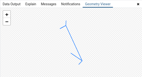
2022 / Day 26: Island(s)
Sometimes when calculating (for example) isochrones you might find that there are smaller ETA islands nested in bigger ETA seas. Sometimes they make sense, sometimes not, sometimes the knowledge of them is crucial, and sometimes they might simply be and artifact that creeps in because of the density or type of “sampling” points that was used for the drive/walk/flight/crawl/sail/(etc. take your pick)-time/distance/effort matrix calculation.
And the criteria might not even be based on “less time” within “more time”, could be anything else as well. I don’t know… “Islands that contain less than three apple trees. Unless there’s a bakery within 500 meters. And a pub in 100 meters, but it needs to be open on every second Wednesday at exactly 15:22 hours”.
So let’s look at how to smooth these kind of outliers out and remove them.
The preparation of iso-areas themselves is based on the very excellent post by Darafei Praliaskouski titled ‘Isochrones are not Alpha Shapes’ which looks at creating isochrone areas from OpenStreetMap data using OSRM routing and PostGIS.
The isocost (or isoclick for the reason there was no better unit that came to my mind) areas here are calculated in the same manner. For the data there’s a set of 1000 random points generated with st_generatepoints and they have their costs (i.e. kiloclicks) assigned with
(st_distance(bounds.c, d.geom) * random()) / 1000.0 as kiloclicks
meaning it’s the geographical distance in meters measured by
st_distance
between the center of the bounds (within which the random points were generated)
and the particular point multiplied by a
Tambov constant: a random() number
for each point. And then divided by a thousand so we have kilo-clicks.
This is in the CTE called pts and will serve as the cost matrix
Next use st_delaunaytriangles
on the st_collected
points which have their kiloclick value assigned as their z-coordinate
(using a combination of
st_force3d
and st_translate). Because
st_delaunaytriangles does
not drop the z-coordinates we can then extract the isoclick areas using
a combination of generate_series and
st_locatebetweenelevations.
And here you can get non-overlapping time ranges e.g. with:
    ...
    st_locatebetweenelevations(data.geom, d, d + <step>)
    ...
from
    generate_series(<start>, <end>, <step>) d,
    data
or overlapping ranges (“0-to-M minutes”) e.g. with
    ...
    st_locatebetweenelevations(data.geom, <start>, d)
    ...
from
    generate_series(<start>, <end>, <step>) d,
    data
I want my click-ranges to be set at [0, 60, 120, 240, 480, 960] so I go
with:
    ...
    st_locatebetweenelevations(
        data.geom,
        coalesce(nullif(60.0 * pow(2, d - 1), 30), 0),
        60.0 * pow(2, d)
    ) as geom
from
    generate_series(0, 4, 1) d,
    data
With the elevation “hedgehogs” extracted, I’ll force them back to 2D with st_force2d, calculate a st_convexhull for every single one of them, st_union them together, and finally st_reduceprecision to snap the areas to a less granular grid (to avoid any GEOS unpleasantries afterwards). Some of the inputs to st_convexhull might not be polygonizable (a single straight line) and this is where a check with st_isempty comes in handy before moving on with unioning.
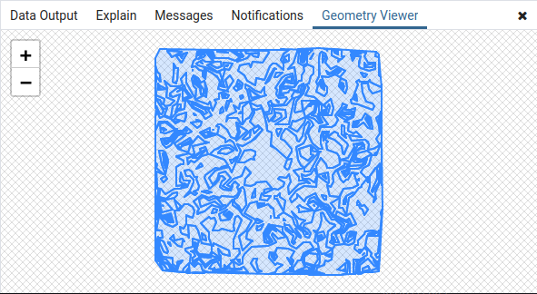
This time around I’ll be looking at how to remove lower click areas (kiloclicks value is smaller) from within higher click areas (kiloclicks value is greater). The other way around (higher within lower), lets say is fine.
I’ll start with extracting all rings of the “isoclick” areas in the CTE
called rings with
st_dumprings which returns
a geometrydump of both, shells and holes as polygons. Add the
outer world boundary derived with
st_expanding the original bounds
a bit larger aswell.
And then in shells will go on to make the preselection
of the islands I want to keep. Which goes like:
I can be a shell if and only if:
- I’m the main shell for the area, meaning i’m st_containsing the centrum absolutum (the bounds centroid that we measuring the clicks against)
- I’m not the main shell, BUT
- there is such an other shell (
othershell) that- is the main shell
- I’m st_within it. Or it st_contains me. No difference which one to check)
- and my clicks is greater than their clicks
- …OR there is no such other shell (
othershell) that- except for the bounds of the world
- I’m st_within it. Or it st_contains me. No difference which one to check
- and my clicks is smaller than their clicks
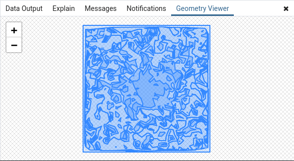
After this selection the number of shells is much lower.
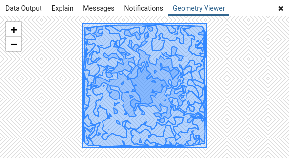
Now for the holes we could go rummaging through the
st_dumprings holes to decide
which holes to keep and which ones not. But there’s an easier way - we can just
take all the shells we selected before and say that these are outershells,
st_union up
all other shells that are
st_within it (innershells,
meaning the outer one will have to have a hole in the same location) but
only in case the outershell is not the same shell and
innershellcost is larger thanoutershellcost
OR
innershellcost is smaller thanoutershellcost but it st_contains the centrum absolutum
and find the st_difference
between outershell and respective innershells. As a final touch
st_union over the cost range
value and apply some
st_chaikinsmoothing for
nicer lines :)
In the end we could be still left with some less click areas on the very
bounds of the area. These are to do with them not really falling into any
of the other shells - these are the borderlands :)
with
    /* minmax defines the corners where we create a set of random points*/
    minmax as (
        select
            st_point(
                40500.000000,5993000.000000,3301
            ) as ll,
            st_point(
                1064500.000000,7017000.000000,3301
            ) as ur
    ),
    /* bounds gives the envelope for them. Extract also the centroid
       that's the source location we'll be measuring everything from*/
    bounds as (
        select
            1 as id,
            st_envelope(
                st_collect(
                    array[ll, ur]
                )
            ) as geom,
            st_centroid(
                st_collect(
                    array[ll,ur]
                )
            ) as c
        from minmax
    ),
    /* pts will hold the random generated points, a total of 1000 pcs.
       kiloclicks is the cost. normally this would be from a routing table/matrix
       or the like, but we'll just simulate it as
       st_distance(source,destination) times a random number between 0 and 1*/
    pts as (
        select
            d.path[1] as oid,
            d.geom,
            (st_distance(bounds.c, d.geom) * random()) / 1000.0 as kiloclicks
        from
            bounds
                join lateral
                    st_generatepoints(
                        bounds.geom,
                        1000
                    ) as p on true
                join lateral
                    st_dump(
                        p
                    ) d on true
    ),
    isoareas as (
        /* create the "isoclick" areas. based roughly on this marvellous post
           by darafei from some years ago that I've been using as a
           "reference-solution" for a long time now :)
           https://www.patreon.com/posts/isochrones-are-20933638*/
        select
            row_number() over (order by d)::int as id, d, p.geom as geom
        from (
            select
                st_reduceprecision(
                    st_union(
                        st_convexhull(
                            st_force2d(geom)
                        )
                    ),
                    0.1
                ) as geom,
                d
            from (
                /* since cost is encoded as the z-coordinate
                   we can extract ranges between elevations*/
                select
                    st_locatebetweenelevations(
                        st_boundary(geom),
                        coalesce(
                            nullif(60.0*(pow(2,d-1)),30),
                            0
                        ),
                        60.0*(pow(2,d))
                    ) as geom, d
                from
                    generate_series(0, 4, 1) as d, (
                        select
                            (st_dump(
                                st_delaunaytriangles(
                                    st_collect(g)
                                )
                            )).geom
                        from
                            pts
                                join lateral
                                    /* turn every point into a 3d point
                                       with z == cost*/
                                    st_translate(
                                        st_force3d(pts.geom),
                                        0,0,
                                        pts.kiloclicks
                                    ) g on true
                    ) del
            ) f
            where
                st_isempty(f.geom) = false
            group by d
        ) g
            join lateral st_dump(g.geom) p on true
        where
            geometrytype(p.geom) = 'POLYGON'
    ),
    rings as (
        /* Extract all rings of the "isoclick" areas + add the
           outer world boundary. All props here are not needed but help
           to make sense on what is going on*/
        select
            row_number() over (order by d, path[1])::int as rid,
            a.id, d, a.geom, pos, path, k.id as bounds_id,
            case when path[1] = 0 then 'shell' else 'hole' end as sh
        from (
            select
                area.id, area.d, r.geom, r.path,
                st_pointonsurface(area.geom) as pos
            from (
                select
                    id, d,
                    geom
                from
                    isoareas
                union all
                select
                    -1 as id, 10,
                    st_segmentize(st_expand(b.geom, 10000),10000) as geom
                from
                    bounds b
            ) area
                    join lateral st_dumprings(area.geom) r on true
        ) a
            left join bounds k on st_within(k.c, a.geom)
    ),
    shells as (
        /* AND here we have to make up our mind which outer shells of
           our rings we'll consider eligible to stay*/
        select
            d.d,
            d.geom,
            d.id, d.rid,
            d.geom as shell,
            d.pos, d.bounds_id
        from
            rings d
        where (
            /* I can be a shell if and only if: */
            /* 1) I'm the main shell for the area,
               centered around the centrum absolutum
               OR...*/
            (d.bounds_id is not null and d.path[1] = 0) or (
                (
                /* 2.1 I'm no the main shell but there is such another shell that
                   - is the main shell
                   - i'm within it
                   - and my D is greater
                   - ... and it's not me myself*/

                    d.bounds_id is null and d.path[1] = 0 and
                    exists (
                        select 1
                        from rings othershell
                        where
                            othershell.bounds_id is not null and
                            st_within(d.geom, othershell.geom) and
                            d.d > othershell.d  and
                            d.rid != othershell.rid
                    )
                ) or (
                /* 2.2 ...OR there is no such other shell that
                   - except for the bounds of the world
                   - i would be in it
                   - and my D is smaller
                   - and it's not me */
                    d.bounds_id is null and d.path[1] = 0 and
                    not exists (
                        select 1
                        from rings othershell
                        where
                            othershell.id != -1 and
                            st_within(d.geom, othershell.geom) and
                            d.rid != othershell.rid and
                            d.d < othershell.d
                    )
                )
            )
        )
    )
/* And pull it all together. Now we could go looking for holes aswell and
then combine correct shells and correct holes. but I think it's much more easier
just taking the shells and then cutting holes into the shells at the places
where they need to be cut*/
select
    row_number() over ()::int as id, d,
    st_chaikinsmoothing(d.geom,2, false) as geom
from (
    select
        d, st_union(dmp.geom)  as geom
    from (
        select
            outershell.d,
            coalesce(
                st_difference(outershell.geom, innershell.geom),
                outershell.geom
            ) as geom
        from
            shells outershell
                left join lateral (
                    select
                        st_union(innershell.geom) as geom
                    from
                        shells innershell
                    where
                        /* the outer shell is not me-myself*/
                        outershell.id != innershell.id and (
                            /* inner shell cost is larger than
                               outer shell cost*/
                            outershell.d < innershell.d or

                            /* inner shell cost is smaller
                               than outer shell cost
                               but it's the centrum absolutum*/
                            innershell.bounds_id is not null
                        )  and
                        st_within (innershell.geom, outershell.geom)

                ) innershell on true
            where
                outershell.id != -1
    ) s
        join lateral
            st_dump(geom) dmp on true
    where
        geometrytype(dmp.geom) = 'POLYGON'
    group by
        s.d
) k
    join lateral st_dump(k.geom) d on true
;